About: Tide Times and Tide Chart
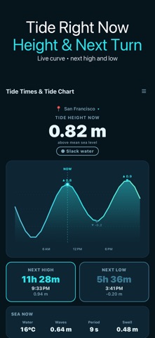
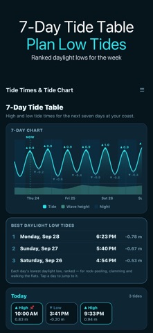
See what the tide is doing right now and for the next seven days: the height this minute, whether it is rising or falling, a countdown to the next high and low, and a clean 7-day tide table you can plan around.
Tide Times & Tide Chart is built for anglers, surfers, paddlers, clam diggers, beachcombers and anyone who times a day at the coast around the water.
TIDE NOW
• Current height above mean sea level, rising / falling / slack
• Today's tide curve with a NOW marker
• Countdown, time and height of the next high and the next low
• Beachcombing window when a low tide in the next 12 hours exposes the shore
• Sunrise and sunset
SEA NOW
• Water temperature, wave height, wave period and swell for the spot you are viewing
• °C or °F follows your metres / feet choice
SOLUNAR FISHING TIMES
• Two major periods (moon overhead and underfoot, about 2 hours each) and the minor periods around moonrise and moonset (about 1 hour)
• The period running now, or the next one, is highlighted
• Traditional angling guidance from the moon's position, not a promise of bites
7-DAY TIDE TABLE
• Every high and low for seven days, grouped by day, with a 7-day chart showing day and night and wave height
• Lowest daylight low tides: each day's lowest low that falls in daylight, ranked, so you can pick the day for rock-pooling, clamming or walking the flats
• Tap any high or low to pin a reminder before it (up to 8 pins)
SPOTS AND ALERTS
• Search any coast by name and save up to 10 spots; plan the weekend from home
• If a place has no tide data (usually inland), the app shows the nearest port in its list that does, with the distance, and switches to it in one tap
• High-tide and low-tide alerts 30, 60 or 120 minutes ahead
COAST
• Spring / neap indicator from the moon phase, today's tide range and tide coefficient
• Metres or feet everywhere; share a tide report as text
HOW IT WORKS
Tides, waves and water temperature come from the Open-Meteo marine forecast model for the position you choose, up to seven days ahead. No account or sign-up. Without a connection the app shows a clearly marked sample curve, not real tides.
A NOTE ON ACCURACY
Heights and times are model estimates above mean sea level, not readings from a local harbour gauge and not chart datum. Exact highs and lows can differ at your beach, in coves and in estuaries. This app is a planning aid and is not for navigation.
 ru
ru
 English
 Español
 Русский
 Deutsch
 Français
 العربية
 Italiano
 Türkçe
 Polski
 Português
 Indonesia
 日本語
日本語