The eGPS Calc app is the premier mapping, area calculation, distance calculation, tracking, & documenting app. Useful for all outdoors activities: hiking, geo-caching, surveying property or landscape, hunting, etc. This app allows you to put all your tasks on one map for easy identification and documentation.
-Map any path or area!
-Track coordinates for anywhere you go!
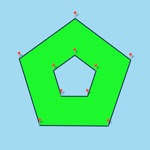
-Calculate the area of any shape! Useful for walking property, landmarks, etc.
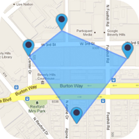
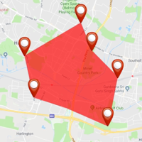
-Display the complex area on a satellite map or a street map.
-Calculate and map the path for any sets of coordinates.
-Document (save, email, text message, export to DB) your travels, and view them together.
-Add pictures (either overall pictures or pictures at each point).
-Map multiple paths, points and shapes together. Useful to see how they relate to each other visually, as well as to compare areas and distances. This adds markers (with names) for each item you map.
-Calculate in either Imperial (ft, sq. ft, acre, mi, sq mi.) or Metric (m, km, sq m, sq km) measurements.
-Ability to manually add GPS points.
-Ability to edit or delete previously saved shapes.
This app allows you to walk, drive, bike, etc… any shape or any path. You can take / save pictures of your overall area / path, or at each point along the area / path. They are saved with your shape. Once you save your area or path, you can view it on a map (either satellite or street view) individually. You can also place multiple saved areas / paths together on one map for viewing. You have the ability to email the information (.csv file of coordinates for use in Excel or other program plus all your pictures on one easy place). You can also export or sms text message your information.
Disclaimer: This application will map and calculate your areas, paths, and points based on the GPS your phone provides and approximate algorithms. Area / distance are not always 100% exact and should not be used for critical applications. The app uses the best available advanced algorithms to translate GSP coordinates onto a flat plane for calculating area and distance and it uses WDS1984 as it's base. However, please note that this contains aggregate values and some approximation does occur.
By downloading this application, you acknowledge that you are solely responsible for your use of this app and data collected, you voluntarily accept all disclaimers, and you agree to hold the application authors and owners, including Workman Consulting LLC harmless and without liability from any losses, expenses, claims and damages of any nature. The authors, owners and developers of this application hereby disclaim all responsibility and liability for this application, its content and its use
 ja
ja
 English
 Español
 Русский
 Deutsch
 Français
 العربية
 Italiano
 Türkçe
 Polski
 Português
 Indonesia
 日本語
日本語