GPS Marine Charts App offers access to charts covering Germany (derived from BSH(Bundesamt für Seeschifffahrt und Hydrographie) data) with POI layers created from ENC charts. Only marine GPS app to have route assistance with Voice Prompts for marine navigation. It has route manager to create new boating routes or import existing GPX/KML routes. It supports Nautical Charts course up orientation.
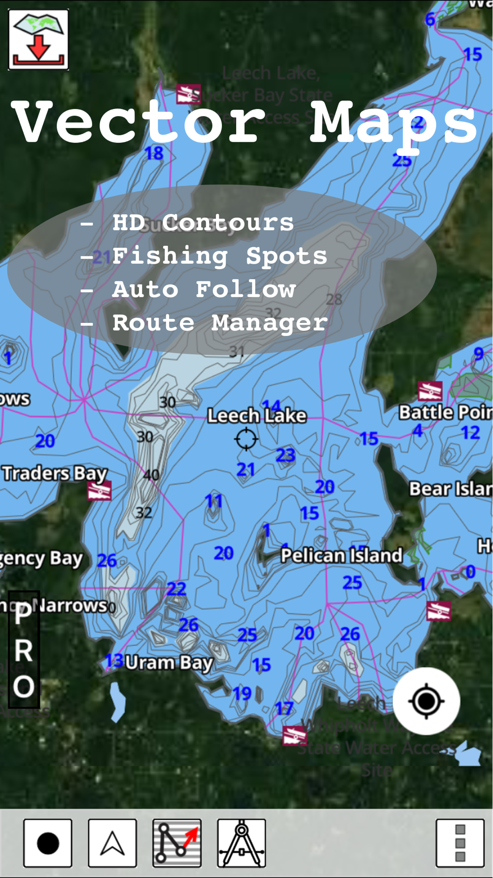
* Voice Prompts for marine navigation (requires GPS )
-prompts when approaching a boating route marker
-Continous distance and ETA updates
-Alerts when sailing/boating off route
-Alerts when boating in wrong direction
*** For any question, contact support at gpsnauticalcharts.com / http://www.gpsnauticalcharts.com ***
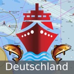
*Route Editing/Creation
-Create routes from scratch
-Edit existing GPX/KML routes.
-Add custom description to any route point.
-Drop markers along route.
* Offline German charts. Charts are created from BSH ENC data.
-Visually draw area to download
-Textual search
-Catalog (North Sea, Baltic Sea)
-Charts reprojected for WGS84 datum
*Seamless chart quilting of marine charts
*Distance Bearing tool
*Create custom way points
- Using GPS
-Select point on map
-Manually enter latitude & longitude coordinates
*POI layer for marine charts
- Overlay POIs
- POI list derived from the equivalent ENC and contains all categories including Buoy, Light, Harbour facility, Obstr.
*Search POIs/Way points
*Pan/Zoom/My Location
* Record Marine GPS tracks
* View tracks overlay
* Live track animation
* Track analytics/stats
* Export GPX tracks.
-Export to SDCard
-Share GPX trakcs with friends.
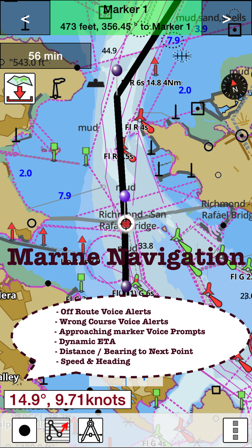
* Auto Follow Mode (Course up)
-Continuously updates boat's location on chart
- Adjustable update frequency
Sample Nautical Charts (please visit http://gpsnauticalcharts.com/main/folio-catalog-nautical-charts-app for complete list)
Lauterbach
Gager
Peenemuende
Vierow
Ruden
Kröslin
Wolgast
Peenestrom / Negenmark Rinne
Peenestrom / Der Strom
Uecker
Berndshof
List
Hoernum
Amrum
Dagebuell
Wyk
Schluettsiel
Helgoland
Buesum
Meldorf
Eider
Pellworm
Strucklahnungshoern
Husum
Dove Harle
Rendsburg
Cuxhaven
Brunsbuettel
Glueckstadt
Hamburg
Stadersand
Bremerhaven
Oldenburg
Elsfleth and Hunte Mouth
Brake
Bremen
Wilhelmshaven
Fischerbalje and Borkum
Norddeich
Norderney
Langeoog
Bensersiel
Emden
Ems Southern Part
Wendtorf
Kamp to Karnin
Eidersperrwerk
Toenning
Friedrichstadt
Baltic Sea
German Bight
Waters north of Kiel
Mecklenburger Bucht
Waters west of Ruegen
Waters east of Ruegen
Waters north of Helgoland
Waters south of Helgoland
Flensburger Foerde
Geltinger Bucht
Eckernfoerder Bucht
Schlei
Fehmarn Belt
Luebecker Bucht
Neustaedter Bucht
Wismar Approach
Rostock Approach
Saaler Bodden
Stralsund Approaches
Northern coastal waters of Ruegen
Sassnitz Approach
Greifswalder Bodden
Greifswald Approach
Usedom
North Frisian Islands northern part
North Frisian Islands southern part, Eider Approach
Helgoland Approach
Jade and Weser Approach
Elbe northern part
Kiel Canal
Kiel Canal Approach
Elbe southern part
Weser northern part
Weser southern part and Hunte
Jade
Juist to Spiekeroog
Ems Approach
Ems Northern Part
Dollart
Flensburg
Fahrensodde
Gluecksburg
Schausende
Langballigau
Gelting
Schleswig
Stexwig
Fleckeby
Missunde
Lindaunis
Arnis
Kappeln
Maasholm
Schleimuende and Olpenitz
Damp
Eckernfoerde
Kiel
Marina Lippe
Heiligenhafen
Burgstaaken
Grossenbrode
Marina Groemitz
Neustadt
Niendorf
Luebeck Harbours
Wismar
Timmendorf
Kirchdorf
Boltenhagen
Rostock
Kuehlungsborn
Stralsund
PLEASE NOTE: Continued use of GPS running in the background can dramatically decrease battery life.
 en
en
 English
 Español
 Русский
 Deutsch
 Français
 العربية
 Italiano
 Türkçe
 Polski
 Português
 Indonesia
 日本語
日本語