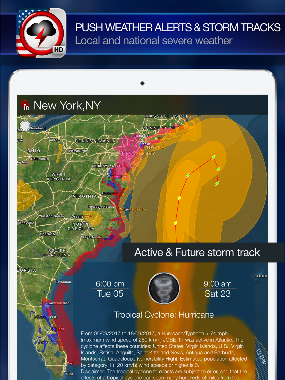
Weather Alert Map is the only app you need for the latest severe weather information. Get the latest Severe Weather Warnings, Watches, Advisories using instant PUSH technology, check radar images and storm tracks, view historical climate details so you’re always aware of weather on the way! Check LIVE storm track, future path and get critical weather alerts for your location in easy and intuitive way - directly on the map.
App offers High-resolution, predictive (future) weather radar, Satellite images of national and local cloud cover, current weather conditions, 10-day and hourly weather forecasts, Lightning tracker, Sea surface temperature, Tide predictions, Air quality and Earthquakes via In-App purchase. Stay ahead of severe weather wherever you are with the Weather Alert Map application!
With Alert Map you will see all watches, warnings, and advisories issued by the National Weather Service. They cover just about anything you can think of including, air quality, avalanches, blizzards, floods, earthquakes, high winds, hurricanes, thunderstorms and so much more.
You will see these warnings color coded in the affected areas on the map. If you tap on it, you will get a summarized version of the advisory or warning, and you can tap it for more detailed information.
Key Features (Free):
• PUSH notifications for multiple locations
• Interactive vector-based severe weather alerts and details.
• Advisories, watches, and warnings for: Severe Storms, Tornadoes, Wildfires, Earthquakes, Winter Weather, Extreme Temperatures, Tropical Storms, Hurricanes, Typhoons, Volcanoes, Tsunami, Wind, 911 Outages, Fog, Flooding, Civil Emergencies, Nuclear Power Plant Warnings, Law Enforcement Warnings, Local Emergencies, Child Abduction Emergencies, Avalanches, and more.
Radar (IAP):
Displays animated weather radar around your current location, allowing you to quickly see what weather is coming your way.
• Past, current and future weather radar images.
• High resolution radar. Stunning and sharp images.
• Full, animated radar from the NWS for the entire U.S.
Satellite (IAP):
Satellite images provide an excellent view on the clouds in the sky and an indication of the weather over the North American continent, Europe, Japan, Indonesia and Australia.
• Satellite data comes from GOES, European and Japan satellites
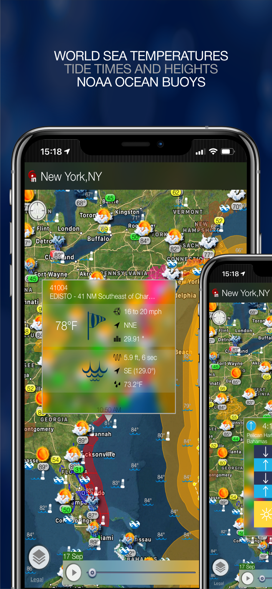
Sea surface temperature (IAP):
Provides useful information for Fisherman, Divers, Surfers, Sailors, Lifeguards, boaters, and anyone that needs to know the water temperatures near them.
• Provides sea surface temperature based on buoys and satellite maps
• Provides zoom and pan functionality
Tide prediction (IAP):
• Times and Heights for high and low tides for thousands of ports, harbors and popular coastal locations around the world.
Air Quality (IAP):
The Air Quality Index (AQI) is a forecast, updated hourly, of what the 24 hour average AQI will be for the current day.
• Provides air quality data for the U.S, includes levels for fine particles, ozone and etc.
Weather (IAP):
Allows you to easily pan and zoom so you can get unmatched detail of weather in your neighborhood or half a world away.
• Provides current weather conditions and a weather forecast up to 10 days ahead for cities all over the world.
• Current weather conditions and temperatures on top of the interactive maps
• Long-term 10-day weather forecast, hourly forecast
Earthquakes (IAP):
Provides near realtime updates of the latest earthquakes across U.S., Worldwide.
• Generates a real-time map of earthquakes that have occurred over the past day in the world. The map includes the the strength of any earthquake with a magnitude over 1.0.
• Uses data from multiple agencies worldwide, including the USGS, and the EMSC.
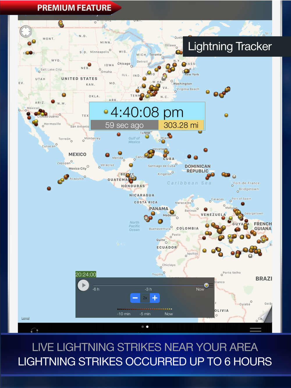
Lightning Tracker (IAP):
• Live lightning strikes near your area
• Lightning strikes occurred up to 6 hours
 en
en
 English
 Español
 Русский
 Deutsch
 Français
 العربية
 Italiano
 Türkçe
 Polski
 Português
 Indonesia
 日本語
日本語