Earth Explorer is a 3D Globe with Augmented Reality (Control View with your device’s sensors GPS/GNSS, Accelerometer, Gyroscope, Compass, other)
Users can load local vector data to the map
Supported file formats are:
GeoJSON
KML/KMZ
GPX
CZML - Cesium Markup Language
CSV - Comma Separated Value Text file - with Latitude and Longitude fields (Decimal Degrees Geographic WGS84)
JSON Catalog files - data layers defined in a JSON file. We provide tool to create these files.
Users can load online mapping services (type or paste in the URL):
ESRI Dynamic REST Mapping Services (MapServer, FeatureServer,ImageServer)
OGC Mapping Services (WMS, WFS, WCS, WMTS)
Raster Tile Servers - XYZ URL
Vector Tile Server - XYZ URL
Support for Open Data Sites
Search CKAN/CSW/SOCRATA OpenData Sites if Catalog file imported
Support for OGC SOS -Sensor Observation Service
- Internet of Things (IOT) Sensors
If users have Vector Data in other formats, they can upload to our server and have it converted and sent back to app/map as GeoJSON.
App Features:
Measure Linear and Area
Search and Geocode
Raster Tile Basemap Picker - uses BING Maps, Open Street Map, CartoDB Basemaps, Stamen Basemaps, ESRI Basemaps
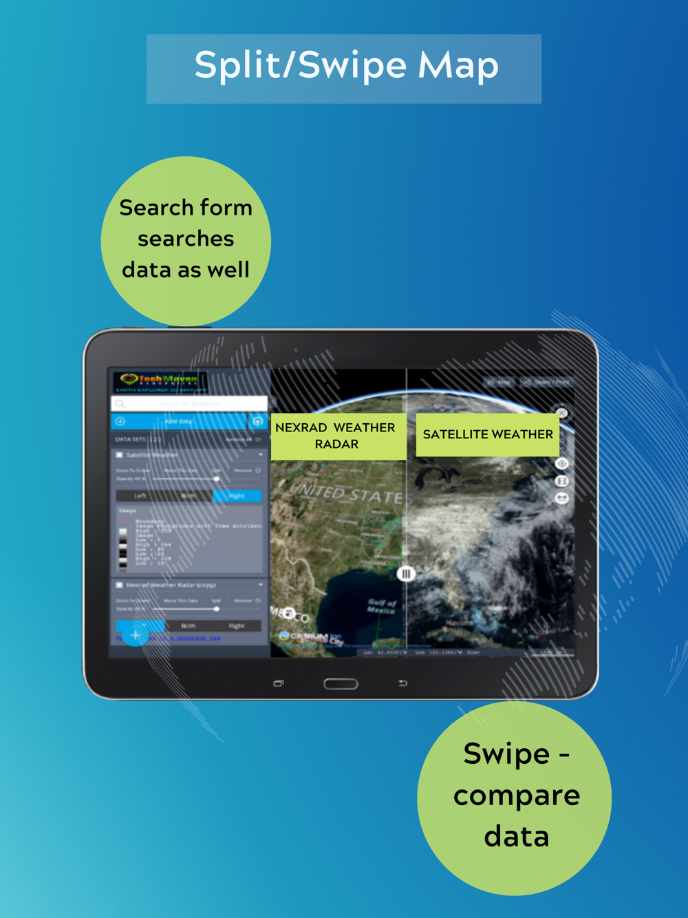
Split/Map Swipe to compare layers
Switch map between 3D Terrain, 2D or 3D Smooth
Geolocation show your location on the map
Tilt Map
Rotate Map
Table of Contents and Map Legend and ability to re-order data layers by dragging
Displays Coordinates in Lat Long or UTM
Drop Markers
Copy Lat Long
Ability to download tables from data loaded
Zoom to Extent of Data
Charting
Timeslider on Spatialtemporal datasets
View Metadata (data about data)
Re-Order Table of Contents Items
Support for offline raster tiles from mbtiles and gpkg
Support for offline vector tiles mbtiles(vector tiles lines and polygon only. Points NOT supported)
Context Capture/Digital Twins/Reality (3D Buildings, 3D Features, 3D Point Clouds LiDAR)
Support for OGC 3DTiles optimized format this can be streamed from server or loaded as zip file named 3DTiles
( Batched 3D Model (b3dm), Instanced 3D Model (i3dm) ,Point Cloud (pnts),Composite (cmpt) )
Support for gltf/glb 3D Models
Learn more http://earthexplorer.world
We have a support site http://support.techmaven.net
Another great app by Tech Maven Geospatial, LLC http://techmaven.net
 en
en
 English
 Español
 Русский
 Deutsch
 Français
 العربية
 Italiano
 Türkçe
 Polski
 Português
 Indonesia
 日本語
日本語