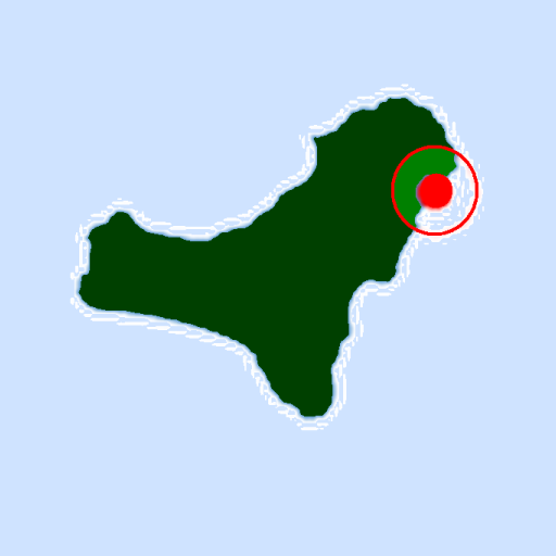
Closest stops from your location, Guaguas Municipales de Las Palmas de Gran Canarias, Canary Islands, Spain, Europe.
The application provides a list of bus stops, ordered by proximity to the device.
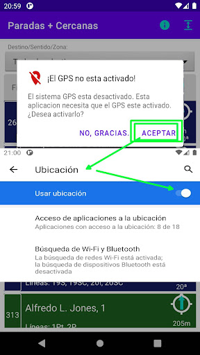
Therefore it is necessary:
1. Activate GPS
2. Grant you location permission.
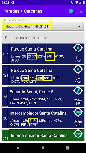
For each stop, it shows:
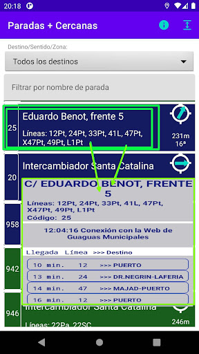
• Stop code
• Name of the stop (street and number)
• Lines and destination (17Tt: line 17, destination to the Theater[Tt])
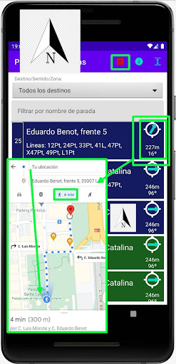
• Linear distance in meters and heading (azimuth) from the device to the stop (332m 42º)
• Icon indicating the heading (azimuth) from the device to the stop (42º). For the icon to be consistent with its surroundings, you will need to orient your device to north. In case of difficulty in orienting, click on the icon.
For each stop:
• If you click on the element, you get a connection to the municipal bus website, and you'll get the waiting time for each service and its final destination.
• If you click on the icon, you get a connection with Google Map, indicating the shortest route on foot, from the location of the device to the chosen stop.
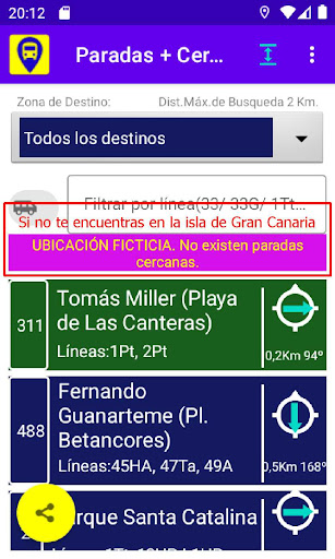
Filter of destinations or zones.
Initially it grants all stops, regardless of their lines and destinations. Using the selector, you can select:
• University of Tafira: Those stops that pass lines to the University Campus of Tafira.
• San Telmo (Global), Teatro, Hoya de la Plata: Those stops that pass lines to the indicated areas.
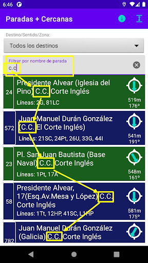
Stop name filter
Initially grants all stops, regardless of their name. You can filter the name field, for example:
• Albareda
• Lion and Castle
The filter is tick sensitive. Part of the name can be specified (Albar = Albareda).
Maximum distance
The application grants the closest stops, with an initial maximum distance of 7,000m. (90 minutes walking).
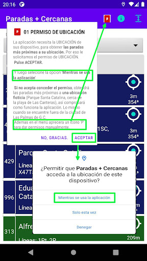
Location or location permit
When an app is using your phone's GPS location, the Location icon appears at the top of the screen.
The application is only useful if you know where the device is, since you have to choose between 900 stops, to select the closest ones. Grant the 'while using the app' permission.
If you don't grant location permission, the app specifies a 'dummy position', so you can learn how the app works.
Privacy policies
The location data is not saved, transmitted or transferred to third parties, except when the icon is clicked and it is connected to Google Map.
Location data is used within the app to locate the closest stops.
The bus stop code from which the lines/destinations and waits are requested is sent to the Guaguas Municipales website, if you click on an item on the list.
Only if you click on the icon of an item in the list, it connects with Google Map, to which the location of the device and the stop will be sent.
The app does not require or use a location in the background, so the Location icon appears when you operate the app and disappears when you exit the app.
https://sites.google.com/view/ego-gc-gua-prd-cercanas
Application addressed to:
• Users of the LPGC Bus Services, outside their usual routes. Or they want to make sure, which is the closest stop to their home or work, or the shortest route to get there.
• Tourists who want to know the distance from their location to the destination stop, and decide whether to wait for the guagua (bus) or walk.
• Users of the Bus Services who want to walk increasing their physical activity, getting off one stop earlier, or getting on one later, and know the time and distance they invest in it.
 en
en
 English
 Español
 Русский
 Deutsch
 Français
 العربية
 Italiano
 Türkçe
 Polski
 Português
 Indonesia
 日本語
日本語