CitySurf Globe is a 3D Virtual globe system. This is mobile version of Windows Desktop Application.
Through OpenGL APIs, CitySurf Globe presents high performance navigation solutions by using hardware acceleration features of devices.
If you want to serve your own raster images or detailed vector based data such as roads, buildings, parcel, poi...etc. you can use Citysurf Globe Server (contact with us).
Try :
- Use Full Globe Navigation. (with 2 finger pinch zoom)
- Tilt and rotate screen by on screen Scroll bars.
- Rotate globe dynamically to north by Digital Compass (Enabled by Pressing Compass icon)
- View feature attribute information
- Display Server side GIS Map Services (wms,wmts,tms,wms-c, digitalglobe xyz)
- Use your GPS and follows your GPS location
- Search and fly to location
- Find Directions between A,B points by using different Providers like MapQuest,OpenStreetmap or CityServer
- Measure Line/Path distance
- Display Sun Position by GMT Time of your device.
- Add new objects to My Places Tree.
- Add Placemark+Photo and send to Community.
Features :
- Supports All size of Android Devices.(Phone and Tablets)
- Display of aeriel and and satellite images
- Working with SRTM, Aster gdem or high resolution local DTM data (geotiff,hgt, dem etc..)
- Vector Object Drawing as Layers. (Points / Lines / Closed Areas / Buildings / Roads etc.)
- 3D Models.(WaveFront Object *.obj)
- Supports Unlimited Size of Data. (Means your server can serve ALL of the world)
- Client side data caching.
- Data collection, editing and sharing
* Intelligent form-based data entry can be designed by Globe Server due to the organization needs
* Attachment of photos, movies, voices to the collected data
* Use of GPS coordinates
- Supports Oracle SDO, Postgres, Esri SHP, MapInfo TAB,MIF
- My Places ( You can draw your own Objects such as points, lines, closed areas...)
They dont deleted when you uninstall application. ( /Phone/CitySurf/myplaces.dml file)
You can copy your myplaces.dml file from Windows Desktop Version of Citysurf to here with same name...
Citysurf Globe PRO version :
These further features are going to be included in the incoming Citysurf Globe PRO version
Access your own GIS Map Services (wms,wmts,tms,wms-c, digitalglobe xyz)
Google Earth KML/KMZ import/export
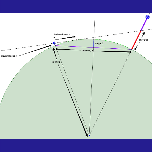
Path Profile / Visibility Analyze Operations
Requirements :
- OpenGL 3D Acceleration. (Real Hardware GPU)
- 64MB Java VM for best performance.
Contact Address:
http://www.citysurf.com.tr
Keywords,Tags :
GIS, 3D Globe, 3D Earth, Map, Mapping, GPS, Navigation, Satellite , Location, Raster, Vector Layer, OGC, WMS, WMS-C, WMTS, WFS, TMS, OpenGL, Client/Server, Sun, GMT, Compass, Oracle, PostGIS, Esri SHP, MapInfo TAB,MIF, 3D, ArcGIS, ArcMap, MapInfo, OpenStreetMap, Google Earth, Terrain, Image Server, Digital Globe, Spatial, City Guide, Harita, Sanal Küre,.
 en
en
 English
 Español
 Русский
 Deutsch
 Français
 العربية
 Italiano
 Türkçe
 Polski
 Português
 Indonesia
 日本語
日本語