We often read, hear and talk about the importance of saving biodiversity, on the pollution of the environment affect the same, about the growth of the population requires to produce more food and this way it alters the natural habitat, home to the biodiversity . But rarely talked about the geological and geomorphological destruction caused by the same reasons especially because of the agribusiness development and constructions. The mechanical erosion destroys the hills, damages the soil, contaminates the water. Various industrial processes of mining, large buildings, move the soil surface, causing losses that will never be recovered. So the very time geographers and soil scientists concerned with the preservation of this natural heritage seek more attention to these spheres in the environmental sciences system.
One way to expand access to information to help protect this heritage is in science communication that MSRS - the Rio Grande do Sul Soil Museums has done since 1983. Located in CCR - Rural Sciences Center UFSM - Federal University of Santa Maria.
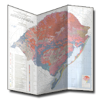
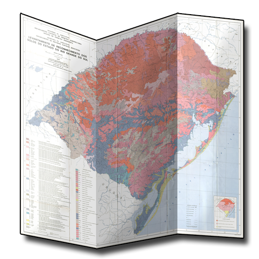
To this end, the application displays the map with the soil mapping units identified in the Survey Recognition of Rio Grande do Sul State Soil report (Brazil, 1973), a more affordable version of the printed, Android platform and with offline access. The interpretation of it is complemented with the third edition of soils of Rio Grande do Sul, created by the authors Edemar Valdir Streck, Ricardo Dalmolin, Carlos Alberto Flores, Egon Klamt, Paulo Cezar Nascimento and Fernando Spinelli.
Thanks to Prof. Dr. John Antoninho Pegoraro Coordinator Course of Technology in GIS Polytechnic College UFSM by scanning the map and the research group of Geography / UFSM PANGEA - Natural Heritage Geoconservation and Water Management for application production.
BRAZIL. Ministry of Agriculture. Survey recognition of Rio Grande do Sul state soil. Recife, 1973.
 en
en
 English
 Español
 Русский
 Deutsch
 Français
 العربية
 Italiano
 Türkçe
 Polski
 Português
 Indonesia
 日本語
日本語