About: VOR ILS GPS
This application is NOT CERTIFIED to be used FOR FLIGHT GUIDANCE.
Use only in Visual Meteorological Conditions.
Do not use as single source of guidance.
The developer is not responsible for damage resulting from incorrect usage of this application.
The developer do not access to you personal information, contacts, or pictures. The application saves a list with your waypoints in the mobile, therefore the access to your file system is required. The ad providers require also non personal information to confirm if a click has been done on an ad. You can read more about our privacy policy in the settings screen of the application.
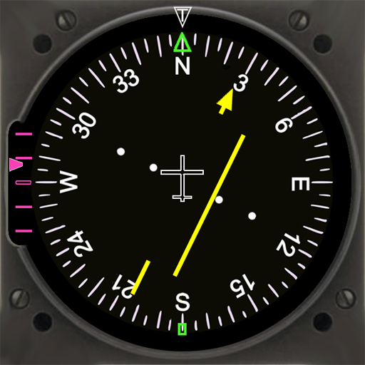
- You must define a reference point: VOR, ADF, NDB, or the touchdown point of a runway.
- The Horizontal Situation Indicator will provide indications to this point.
- The green arrow indicates the heading to the reference point.
- If the reference point is the touchdown point in a runway, the HSI will provide also indications to fly a 3º glideslope to that point (simulating an ILS approach).
- Choose the course you want to follow. The Course Deviation Indicator will diplay a deviation up to 10º each side of the selected course.
- The reference point must be defined introducing its coordinates and gps altitude. You can introduce up to 20 waypoints.
- You can save the coordinates of your current position by pressing the Mark button and importing them as a new waypoint.
Example:
N 40º 22' 12.92"
W 003º 46' 36.4"
Connect the location sensor of your device.
The information provided during the first two minutes (mainly the altitude data) will not be reliable.
Warning: Some devices do not provide gps data when in battery low mode.
 en
en
 English
 Español
 Русский
 Deutsch
 Français
 العربية
 Italiano
 Türkçe
 Polski
 Português
 Indonesia
 日本語
日本語